
We were spending two nights in Gold Beach, which gave us the day to explore the Samuel H Boardman scenic corridor - a long stretch of the southern Oregon coastline dotted with little tree-topped islands, nestled between bays and headlands, hidden beaches around every corner. I'd seen a few shots on Flickr and wanted to find a particular spot, and had a pretty good idea of where it was, so would try to locate it during the day prior to returning to capture it at sunset.
After breakfast in the motel we set off out of town, the weather a little overcast, but with some patchy blue sky. I had expected the road to be prettier (all down the coast, actually), but it was a busy two-lane highway in places, so not exactly the quaint scenic drive I'd hoped for. We drove the length of the road first, deciding to then stop on the way back, pulling in at a couple of the roadside pullouts to enjoy the view.

The first proper stop was Lone Ranch Beach, a long stretch of beach just off the road, with a few stacks in the bay. The light wasn't great, so black and white conversion was in order for a few of the shots.

We continued north, looking for a trailhead that I'd decided on to start a long-ish hike. The plan was to hike from Indian Sands to China Beach and back. The trouble with this park - from a hiking perspective - is that it's spread along the coastline, so any round trip involves retracing steps along the coastal paths or walking along the road. We parked up at Indian Sands and headed north. We got a little lost to start with, ending up at the road a little further along. We walked back to the car and started again, heading this time down towards the sea. We found the trail to the dunes of Indian Sands before coming to an apparent dead-end (with a nice view).


I'd read up on the trail and it certainly didn't end there, so I had a little snoop around and finally found the narrow trail winding up around the side of the headland, so we continued on.


We soon realised that we were going to have to go back up to the road in order to cross the massive bridge at Thomas Creek (the highest bridge in Oregon, at 345ft or 105m); there was no obvious way down to the bottom of the creek and back up the other side. The bridge is pretty long and impressive, and in the middle I stopped to look down - enough to give anyone a little vertigo. Piles of driftwood sat alongside a thread of rivers which glistened in the midday sun.


Finally on the far side we got a good view of the bridge behind us.

On the other side we had the choice to find the trail on North Island (another little headland) or head down through the forest towards China Beach; we chose the latter route.

China Beach is a long stretch of grey-ish white sand with - of course - a series of stacks sitting just off the beach. We sat on some rocks and ate a packed lunch, the sky now nearly completely blue, with just a few wispy cirrus clouds left.


We continued along the beach, noticing piles of pink crustacean shells and barnacle-covered mussel shells. I had a look for cowrie shells but found none :(


The path rose steeply through more pine forests to the road. We had the choice of walking back along the road (the quick but not very nice route) or following the same route back down via Indian Sands. Neither of us had the energy to go down and up again, so we decided to stick to the direct route along the road. I still wanted to stop at some other pull-outs and viewpoints, so this was the quickest way back to the car.
We pulled in to park at Natural Bridges, where I hoped to find the spot that I wanted to scope out for sunset, later on. We walked down through thick undergrowth and came out at a lovely viewpoint overlooking the bridge.

W
We carried on further, hoping to find a path off the trail down to the viewpoint, but it was blocked with a sign saying closed due to nesting birds. Hopes of my perfect sunset shot were dashed. We carried on a bit further but there were no other trails leading us to the place I wanted to see. There were some other decent views, but not the specific one I was hoping for!

W
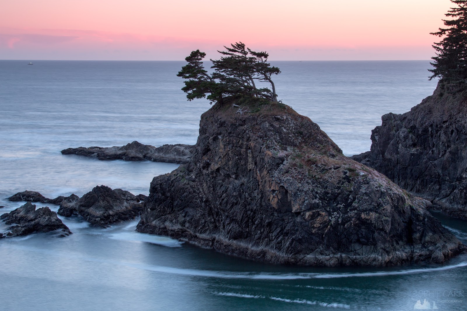
We wandered back up to the car, drove a hundred metres down the road to the next parking spot at Thunder Rock Cove and I headed down the trail to scope out that area; hubby stayed in the car. I came to a lovely little headland, with some natural arches and hidden beaches (one aptly-named Secret Beach) and views north and south. A couple of sea otters floated below the arch. This spot would have to do for sunset, later, although the position of the setting sun was going to be challenging.


We drove back towards town in search of the Arch Rock Brewing Company, which had won a prestigious very small brewery award for one of its beers. We drove into town but couldn't find it, checked Google Maps and drove back out to find it hidden away in a little area called Hunter Creek. The tap room was basically in the entrance-way of the tiny brewery, and a friendly man gave us some samples. We bought a couple of plastic growlers and filled them up with an interesting absinthe porter ("Another State of Mind") and a decent pale ale ("Pistol River Pale Ale"). We ate dinner in town in a strange little restaurant that also stocked the beer, Barnacle Bistro. After an okay meal we headed back to the hotel to recharge batteries and get some thermals for the sunset shoot a little later.

W
We drove back to the Thunder Rock Cove car-park and headed down to the little promontory, the sun still fairly high in the sky. I wandered around the paths to see which compositions I liked the best; nothing truly grabbed me. Eventually I spent most of the following hour capturing the backlit trees on some rocky cliffs above Secret Beach. The rocks to the south eventually began to glow too as the golden hour intensified.


Just before the sun actually began to set I started scurrying around searching for better composition, but the positions of the stacks, islands and the sun just weren't doing it for me. In the end I settled down to photograph the sun on its own, as it passed behind an animal-like cloud before reappearing briefly and then dipping behind the ocean.


After the sun had gone the sky to the north-west glowed a warm peach, and to the south-west the horizon became pink.

T
To the south the rocky crags lost their colour and the sky and sea both turned a lovely soft blue.
To the south the rocky crags lost their colour and the sky and sea both turned a lovely soft blue.

I packed up my tripod and we headed back to the car, noticing that the Mustang sign lit up the ground below, rather unnecessarily!


W
We headed back to the motel and had a quick beer before an early night. The following day we were heading inland, our trip to the Oregon coastline, and the worry in the back of my mind of tsunamis, being left behind us.
If you're interested in visiting this state park - this is a great little booklet to help you!
 |
| Map of the day's route |
Click here for Yachats to Gold Beach blog
Click here for the drive to Crater Lake blog
No comments:
Post a Comment