29 Aug 2016

Road-trip in Oregon - Hiking in Smith Rock State Park

The benefit of having a base for a few days on our Oregon road-trip was that we could do a nice day-hike in the nearby Smith Rock State Park, just north of Bend.


The weather was similar to the previous day - some white, unexciting cloud, with the odd patch of blue sky and sun. We had a long lie in, then headed out at midday (stopping at Safeway to buy some packed lunch food and Walmart to buy a new iPhone charger after I snapped the one we had. We also bought some Kombucha, to try it - it was vile and it got thrown away, undrunk!). The park is just outside the little town of Terrebonne, which is just outside Redmond. On the way we passed my favourite-named road in the area: Odem Medo (who knows why!). Approaching the park the mountains just pop up in the middle of the surrounding farmland and residential area, but it's impressive once you get away from the houses.


W
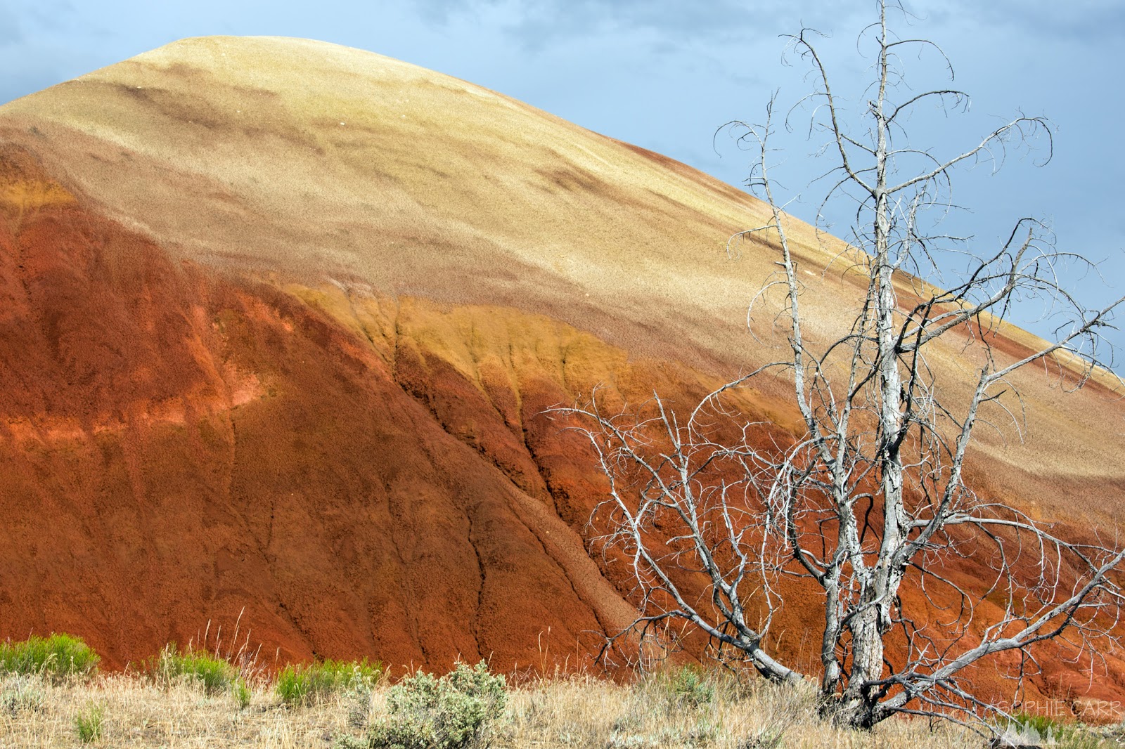
We parked the car, sat and ate some lunch, and then headed down the path to the footbridge, huge craggy yellow and red cliffs towering above on the other side. I'd chosen to do the circular hike in an anti-clockwise direction, going up along the Misery Ridge route, passing Monkey Face, then down the other side and back along the bend in the river. It was pretty hot, but at least the sun wasn't out constantly. As we walked down to the river I realised that I'd put on my non-hiking shoes, by mistake. There was no way I was going to drive back to get my shoes, so I had to make do with my New Balances, which had no grip or tread whatsoever. We climbed steeply uphill, noticing rock-climbers perched to the cliffs. They were everywhere - this was a very popular place for climbing. Every other hiker seem to be carrying a bunch of ropes and carabiners, heading off to find a new wall to explore.


As we walked we chatted to a couple from Portland, who were down for a couple of days. The woman was 8 months pregnant, so was taking it fairly slowly, but she was still managing remarkably well. The boys chatted about craft beer. I took a few photos. We got to the first viewpoint facing east fairly quickly - the distances weren't great.


A
At the top the path wound round a few towering rocks and headed over to the other side, facing west. On the far side it was suddenly really windy. We met a couple of women who were from Wisconsin and had a little dog called Biscuit. The dog's owner said "Awesome!!!!" after everything I said. She was very sweet, but the awesome thing was a little over-the-top.


W
We headed down a bit and found the Monkey Face, upon which we noticed a climber. We found a perch overlooking the wall and crept to the edge of it - directly opposite the little nook that the climber was standing in. There were, in fact, two climbers - one had just made it over a little rim to the sheltered resting place, and the other was miles below, planning his ascent. We watched them for a while, the guy below making a speedy job of getting up, clipping and unclipping carabiners as he went. He got a bit stuck at the top, unable to hoist himself over the rim. After a few goes he finally made it. I took lots of photos of them - it was quite amazing what they were doing!


W
We headed down the back side of the rocky mountains, the wind fierce again as we descended. The view from that point was spectacular.


It was hard work for me in my unsuitable shoes, paranoid that I was going to slip down the loose rocks at any time. I made it down without slipping at all, which was a relief. The remainder of the walk was an easy amble along a fairly flat path, at the foot of cliffs.


Every now and then I'd notice more climbers hanging off the edge of high cliffs.


A line of geese struggled against the current of the river. The path followed the river as it wound around to the south and east back to our starting point. The last area was packed with climbers - little dots of people with outstretched limbs everywhere you looked!


The whole hike took us two and half hours, but we had taken it pretty slowly, stopping for at least half an hour to watch the climbers on Monkey Face. The sky was still overcast, the sun only having come out for brief moments during the hike. I would have stayed around for sunset, but it wasn't for a few hours, and again beer called - we still had to try the Crux Fermentation Project and we were heading off the next day, so this was our last chance.

We drove back and decided to visit a few of the breweries with the car, as they were quite a walk from the house. It meant that Murray was only able to have a few sips of the beer as he was driving (his turn). We started at Boneyard, where a tour bus had arrived before us, so there were queues to get the tasters. There were some nice beers, but Murray was a bit disappointed. We worked our way through the tap-list before heading to Crux.


The beer at Crux was good - we'd been told it was very good by various people we'd met along the way, and it didn't disappoint. While we were there we had some grilled sprouts (delicious!!) and some more of the strange squeaky curd cheese (raw this time, and quite tasty too). Since we still had the car we decided to go home after this, before heading back out for something to eat and more beer later.


A
At home it was our last chance to use the hot tub, and it had turned into a lovely sunny evening. We sat in the tub, drinking the Rogue beers we'd bought a few days earlier out of our metal cups from the Portland festival, finally getting to wear my new bikini. It was quite blissful!


Hunger arrived, so we headed back into town, across the river which looked so serene.


W
We ate a reasonably good Thai meal at the Wild Rose - one of the few restaurants in town, which was heaving. Then we walked across town a little to get to the Platypus Pub, where a quiz night was going on. It was quite lively in the main room, but we sat at the bar and worked our way through the tasters - they had a great selection from a variety of breweries.

"Drink Til You're Nice"

W
We headed back to our little pink home for the last night.

Map of the day's drive

Click here for my blog on visiting the Blue Basin & Painted Hills

Road-trip in Oregon - Painted Hills & the Blue Basin

Day 11 of our road-trip in Oregon saw us doing a rather long day-trip from Bend, into the desert to the east, in search of colourful 45-million-year-old fossil beds. When researching and planning the trip I'd hoped to visit a desert in the far south-eastern corner of the state, but again it was slightly too early in the summer, with some roads (and therefore views) not yet open. The other area of interest I noticed, though, was about a 250 mile round-trip from Bend - the John Day Fossil Beds state park. Quite a long way, but just doable as a day-trip.

 We set off relatively late, picking up some extremely disappointing pastries in a bustling café in town, La Magie (maybe we're just spoilt for choice with decent pastries in London, but these were terrible!). We ate the crumbling pain au chocolat and apple turnover in the car as we drove. It looked like an easy route - up to Prineville to connect with the Route 26 that took us all the way there; that was until we discovered the road works. There was a 30-or-so mile section where the road had been or was being resurfaced, and for most of that section the speed limit was 30 mph. Not fun. Eventually we passed it and reached a little pull-out at Mitchell, not far from the turn-off to Painted Hills. We wanted to get to the Blue Basin first, and then visit the Painted Hills on the way back, but stopped here for lunch. There was a tiny roadside café (Bridge Creek Café) that was already full at midday; there's not much else on the road for about 50 miles in either direction, so I guess this wasn't surprising. We ordered a couple of sandwiches and were told that they'd "just run out" of fries and pastrami. We heard the same thing a few more times as others ordered. The food took forever to come - it was just a woman doing the cooking and her daughter serving. It was pretty tasty and cheap, and there certainly weren't many other options around (although we did realise that there was a "downtown" Mitchell just off the road on our way back that might have had other food options).

We continued on, still with a way to go to get to our first destination - the Thomas Condon Paleontology Center. The John Day Fossil Beds is a strange state park spread out over a few locations in the centre of Oregon. In 1864 it was discovered that there were layers of different material deposited from different periods in history, and each of which contained a fantastic record of animal and plant species that lived during that time (between the late Eocene, about 45 million years ago, and the late Miocene, about 5 million years ago). Paleontologists had discovered a whole new variety of animals that hadn't been know about before. We had a slow wander round the fascinating museum, learning about all sorts of animals that lived in those eras, including some early horses and camel-like mammals.

Keen to move on and see some of the fossil beds we drove a few miles north to the Sheep Rock Unit, where the Blue Basin is found. We took a short walk up a boardwalk trail that led us through some weird blue-green rocky badland structures. The light was dreadful - early afternoon, with grey/white, overcast skies, so the photos weren't exactly stunning. We could have taken a longer walk that took us around the edge of the basin for a better view, but neither of us really had the energy, so we stuck to the short, relatively flat path.


Some of the detail in the rock was fantastic, and it was strange to think of other fossilised remains of animals and plants from millions of years earlier still trapped within the rocky cliffs. The hillsides surrounding the Blue Basin were covered in pretty wild grasses and there were some decent basalt columns on the hills nearby.


I drove back towards Mitchell, through a windy canyon, pulling over to photograph a strange tree I'd noticed on the way, totally covered in shoes - who knows why! I certainly wasn't going to add to it. We eventually got to the Painted Hills area at around 4.45pm. The light was getting a little better; although the clouds were still pretty dense the odd patch of sunshine appeared.


We parked up by the first viewing point (aptly named Painted Hills Viewpoint) and walked up the hill to see the rolling orange and red hills in the distance. It was extremely windy, which it hadn't been at the Blue Basin, reminding me almost of Icelandic winds!


The angles of the hills from that viewpoint weren't great; I preferred the view from the road as we came in, which we'd stop at on our way out. We walked back down to the car and drove on a little way along Bear Creek Road to the trailhead for the Red Hill Trail. This was a short trail to see a stand-alone red hill (the clue is in the name in these places!). I loved this triangular hill - the patterns in the rock were wonderful, with colours streaking down the sides. At the foot of the hill were some picturesque dead trees and shrubs. I could've spent days there photographing it from every angle (although this wouldn't be possible as its protected and you can only go on a few trails on one side). The sun came out from time to time, which was welcomed, intensifying the red colour momentarily.


Behind the Red Hill was a white and maroon one - the colours were just bizarre!


W
We stopped at a couple more viewpoints before it was time to take the long drive back to Bend, already 6pm, just as the light really was getting richer. The patterns were incredible and the view just near the entrance really highlighted the rolling and stripey nature of the hills. A couple of people at the foot of the hills would've been good, for scale, but as I said before, people were restricted to the paths, so that wasn't possible.


The drive on the way back was still slow with the new road-surface slowing us down. We drove with the roof up, which was far more pleasant when it was a little chilly outside. Murray fell asleep, and I had to concentrate on not doing the same (I was driving back). The sky had now turned incredible with weird clouds everywhere, including some lenticular ones. Had I been on my own I probably would've taken a detour to Smith Rock State Park to capture the sunset, but hubby had beer on his mind (when he woke up).

We got back to the house, left the car and headed down to a little industrial area to the south of the centre that had been redeveloped.


W
We ate in a newly opened brewery - Immersion Brewing, with me nipping outside from time-to-time to check the sky and take a couple of iPhone shots (I was quite grumpy about missing this amazing sunset).


The food was pretty tasty - if a little pricey (the special of Thai Prawns was $20 and contained only 4 king prawns!). The short rib on a black bean cake was delicious. The beer was okay, although a little lacking in oomph.


After supper, at 9.15pm, we wandered along the road to the Crux Fermentation Project, which very disappointingly was closed, even though their entry on Google Maps showed them open until 10pm on a Monday night (hubby emailed them and they've now updated it, to prevent the disappointment of others!). We walked back into town and the only place open (yes!) was the Deschutes Brewery - a huge bustling place. We sat at the bar and had a flight of tasters, trying not to pick the ones we'd had the previous week at the Pearl on Pint festival in Portland. After the long drive we were both a bit knackered so we headed back after that for an early night.

Map of the day's drive


Click here for my blog on Crater Lake to Bend
Click here for my John Day Fossil Beds blog