My first full day in Iceland's Westfjords was going to be a fairly relaxed one - partly because I didn't have far to drive, and partly because it was raining and I wasn't in the mood to spend too much time out in the elements. I had two sights on my to-do list: the Látrabjarg cliffs (knowing that the birds had unfortunately left a couple of weeks earlier) and the Rauðasandur (red) beach, with its amazing swirly sandbank patterns. I got up at around 9am, headed upstairs for a delicious breakfast (waffles, amazing home-made bread, decent home-made jams, and the usual bits of other buffet stuff), chatted to a friendly Austrian couple and Finnish girl that had just started working there, then returned to my room with the task of
cleaning my sensor ahead of me. I usually do this before I go away, but I'd been so busy at work before I went that I hadn't got round to it. I brought my little kit with me (a little gel cube on the end of a stick and some pieces of sticky paper) and set to it. I had a particularly stubborn spot in the top right hand corner of the photos, so my aim was to get rid of this one, and the other less-obvious ones. It's not very intuitive to work out where on the sensor the dust spot is, and I'd googled a couple of times and thought I understood it (it's flipped vertically), but then I got confused and thought it was flipped horizontally too. I spent a while squidging the gel cube against the wrong corner (over and over!) - no wonder the stubborn spot was still there. I googled the article again and then realised that I'd misunderstood - so for anyone with the same question as me - if it's at the top right-hand corner on a photo, then the dust is at the bottom right-hand corner as you look at the sensor from the front of the camera with the mirror open. Finally after about an hour I'd not only shifted the difficult spot, but the sensor had never looked so clean! It would save me a lot of irritating time post-processing, cloning out countless dust spots.
So, once the sensor was clean I made myself a little packed lunch (the usual - grainy rye bread with cheese and ham), filled up my water bottle (I took an old one with me, so no new plastic used on this trip!) and started the potentially-tricky drive to the big cliffs. The rain had cleared a bit, but the air was still damp and a bit drizzly. I'd read a few blogs about how hairy the drive was, so I felt pre-warned: sheer drop-offs, lots of bends and switchbacks, few barriers to prevent you careening off the edge of the narrow roads, rockfalls, not to mention huge, water-filled potholes and sharp rocks pointing up waiting to burst your tyres. I set off just after midday - not the earliest of starts, but the heavy rain had at least stopped (for now!).

The beginning of the drive was obviously the quickest and easiest - winding back along the tarmac road to the bottom of the mountain pass, before turning right to meander along the south side of the fjord. I stopped near the turn-off, as there were some beautiful waterfalls trickling down on the cliff ahead of me. The vegetation was just beginning to turn a little, but I was still way too early to get any decent autumn colours. One last lupin reminded me of what I might see if I actually came in summer time.
The car even got its picture taken, with the fantastically stripy, steep hillsides in the background.

The gravel roads began, although to start with they were fairly easy, with just a few potholes. I soon noticed the back window being covered with muddy spray; the windscreen wipers and cleaning fluid had their work cut out for them. The first stretch took me under the scree slope in the above picture, which looked scary from a distance, but for some reason I felt fine about driving along these roads. I think my previous year's trip in the north-east driving across many mountain passes in low visibility must have given me more confidence. My next stop was at a bend where I could see the mountains and road spreading out into the distance. I pulled in near a farm where there were some hay bales that weren't covered in hideous plastic, which made a nice change (although obviously they were open to the elements). The drizzle didn't show any sign of letting up, even though the forecast had said it would be dry after midday.


I carried onwards, avoiding the temptation to stop every few hundred metres to photograph a stunning bit of road, and continued on past the shipwreck (I'd stop later), the turn-off to Rauðasandur, the massive sandy beach that I'd seen from town (which actually has a little airstrip on it), and on until I reached a big bend where a large white sand bank spread out in front of me. In my planning I'd hoped this looked as good in the flesh as it did from Google Maps and I wasn't disappointed. Having seen so many black or grey sand beaches in Iceland it really was refreshing to see these yellow-white ones - such a difference!! The road was fairly narrow at this point, but there was enough room to pull over and park for a bit. In actual fact, instead of having enough room to pass me, all the other cars just followed suit and stopped to take photos of this stunning sight. In addition to the pale sand the waters were an intense turquoise, even with the grey skies above.

I believe that the beach is called Tungurif, from an
excellent Icelandic map source I've used that shows detailed place names. I stayed for some time, trying new views, driving a little further down the road for a different viewpoint.

The 60km drive from Patreksfjörður to the Látrabjarg cliffs was supposed to take about an hour and a quarter, according to Google Maps, but it took me an hour and a half before I left this beach! I really need to at least double the suggested driving times. The next bit was a bit quicker - heading inland, passing a museum with a crashed DC3 (obviously not quite as cool a position as the one on the black sand along the south coast that you now have to walk 3km to reach) and then uphill and across another fantastic mountain pass (Hjnótsheiði) - the road snaking in every direction. I stopped at the top and took another photo of the car - you can already see how much mud it was being covered in from splashing through water-filled potholes; the soil in the area was very red, so the car had changed colour. Visibility was also dreadful up there, and the drizzle wasn't going anywhere fast.


The road wound down towards Breiðavík beach before heading around the west coast towards Látrabjarg. Before the last stretch there was a stopping area with a loo, near a pretty beach. I popped in to the loo before heading on, stopping to take a picture of the sign as I left - WC with a cross through it, as if WC was the name of a town or village! Not quite sure why I found it so funny - perhaps it was a symptom of being on my own for a couple of days...
 |
| * iPhoneSE shot |
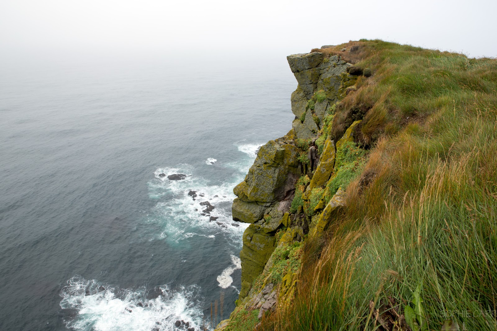
It was almost 3pm before I reached the car-park for the cliffs. I kitted myself up, but decided to leave all the lenses but the one on the camera (24-70mm) in the car, as it was raining, and didn't look as if it was going to stop any time soon (I regretted this later, when the rain did stop, and I could've done with the 200mm reach). I walked up the hill from the car-park, a few people dotted around in the distance, the odd photographer with a tripod here and there. The cliffs were indeed impressive, but must've been far more so when teeming with birdlife (the puffins leave in mid-August, and it hosts one of the largest populations of razorbills, who had also departed already). The cliffs reach 400 metres in height at the highest points - I did peer over the edge and it was definitely a long, sheer way down (a poor man had fallen to his death a few years earlier, so there were signs near the car-park warning people). There was lots of vegetation over-hanging the edge, so it was definitely sensible to stay well back from those precarious edges.


 The place was busy, but only a few groups of people dotted along the clifftop, so it didn't feel crowded. I can only imagine what it must be like on a midsummer's evening with photographers lying along the clifftop trying to get their own "unique" puffin shot... I met a French couple who asked me if I'd seen the macaron (I assume the French for puffin) and I said no, as they left a few weeks earlier, and they said that they'd seen one earlier with fish in its beak. I didn't really believe them, and wondered if this was just something they said to people with tripods, for a laugh. Who knows, maybe there were one or two birds left behind. I certainly didn't see anything other than a few gulls and some rather macabre unidentifiable bird corpses.


I carried on for a while, heading towards some slightly higher cliffs, before getting to a point at which it didn't look much different. The drizzle had subsided and it was actually dry for a while, so I could have changed lenses on the go, after all. A faint rainbow was visible to the north as I looked behind me.
The fog over the path ahead was thick, so after about an hour I decided to turn around and head back.
It was almost 4pm and I still had to drive to - and explore - Rauðasandur.
I stopped to take a few of my silly self-portraits (making use of the heavy tripod I was carrying), not to mention a silly iPhone one... A patch of sun even shone over the sea while I was looking out.
 |
| *iPhoneSE shot with over-dyed eyebrows! |
As I walked back a new flurry of people appeared - it seemed busier than ever.
I walked back to the point, where a lighthouse marks the westernmost point of the European continent (the Canary islands are part of Africa, geographically). Quite something really, the far edge of the continent that I've lived in my whole life.
I got back to the car just before 4.30pm, and headed back across the heath towards my next destination, Rauðasandur, driving through low cloud again, splashing through endless dirty puddles.
I stopped briefly at the museum to have a look at some old boats and the DC3 before continuing on back down the fjord.

When I reached the beach at Tungurif I suddenly realised that I'd totally messed up my upcoming visit to Rauðasandur - the tide was in!! The beautiful wavy sandbank patterns I'd seen a few hours earlier were now gone, as the water obscured them, and I knew that the same would be the case at Rauðasandur too. I didn't have another opportunity on this trip to visit the red beach, so I had to go and see it now anyway, knowing the disappointment that awaited me. The fjord looked lovely as I drove towards the turn-off towards the red beach, with faint grey stripes in the late afternoon light.


I took the turn-off to Rauðasandur and headed up the hill to what I knew would be another tricky mountain pass. Some American women who were staying at the same guesthouse were driving along the same route as me, and we kept stopping to take photos and overtaking each other. As we drove down the steep switchbacks that led down to the beach we smiled as we passed. When I was planning the trip I had hoped to park the car somewhere and climb up to a viewpoint overlooking the beach. That turned out to be a particularly ridiculous idea - even if the weather had been fine, the terrain certainly wasn't!
As expected, I turned the last bend and the beach came into view, but the high tide obscured the wonderful swirly orange patterns. A couple of higher sandbanks could just be seen, but I was still disappointed. If only I'd gone there first (then I would have missed the sand patterns at Tungurif, but I really wanted to see the red ones!).
I turned left at the bottom of the pass and headed to the eastern side of the beach - I'd seen on the map that it was possible to drive quite far to a farm area called Melanes. There was also an impressive tiered waterfall that I wanted to get closer to, which unfortunately was at the end of a private road. I drove as far as I could and parked the filthy car, and headed off towards the beach laden with camera gear. I passed a rather depressing sign, as well as another pretty waterfall (they are literally everywhere).
Soon I was on the red sand, which was actually more of an orange colour (red sounds better, though). There were some little mounds of sand visible in the lagoon, as the tide was beginning to recede a little (at least I didn't have to worry about the tide coming in and cutting me off).
I headed onwards towards the shoreline, passing an unused volleyball net (I was the only person there) and dried-up pieces of seaweed.
When I reached the shore I noticed that the dry sand was actually a darker orange than the wet sand at the shoreline, which was a bit odd. The patterns it made were quite pretty, but it was messy with all the piles of brown seaweed.
I walked along the shore for a little while, the waves shallow and disappointing, before heading inland again. I wanted to see if there was a better view of the beach from the western end. On the way back I passed more sandy patterns, some rather out-of-place green plants and some more tufty grasses in the shallows. Another couple arrived and wandered onto the beach before heading inland again.
From the roadside I took a couple of shots of the waterfall that I couldn't get any closer to, the layered cascades reflected in the river below. I wouldn't have minded renting out one of the little cabins nearby.
From there I could see the road back up the pass, disappearing into the fog. I took another picture of the ridiculously dirty car, the number-plate now obscured.
The road west passed lots of farmland, the beach only just visible from time-to-time in the distance, mainly if I looked back the way I'd come. Fog was clinging to all the hills surrounding me.
I stopped to photograph a quaint church and some cows that were staring intently at me. Some were close but others were far away, standing up on a hill underneath fog draped over pointy peaks.
I reached the last farm and then turned around and started my journey back to Patreksfjörður. I was a little nervous about staying too late, as I didn't want to drive across the heath in both fog and darkness (plus it was still drizzling lightly). I stopped a little way up the first steep section as I could get a better view of the sandbanks that were beginning to come into view as the tide receded. I tried out a few panning shots and liked one in particular.
The light began to fade fast - far faster than the tide was going out, so I had to give up in the end, and just told myself that I'd have to return when the weather was a little better, and when I'd checked the tide times first. Always good to have a reason to come back (although I don't actually need any, as I know I'll return!).
My last stop was at the wrecked ship; it had been teeming with people when I drove past earlier, but now everyone had disappeared (it was already 9pm).
I rushed home after this, and realising that I'd missed the hot food orders at the restaurant from the night before I made myself one of my dull sandwiches for my supper, had a beer and settled down in my room to review the photos of the day. I had a long drive ahead of me the following day, so I had an early night. The weather had been disappointing and restricting, but I'd already had some fantastic drives, seen some impressive cliffs and some stunning beaches. I could see why people raved about this part of the country.
Click here for the blog from
Day 1 - Finally Visiting the Westfjords!
Click here for the blog from
Day 3 - Dynjandi (plus more)!


 To my surprise, other guests began to leave at around 10am. The roads were still closed, and the wind speeds were generally between 16 and 22m/s along the local stretch of road, but obviously with higher gusts. I didn't know if there were any physical barriers along this stretch of road, but I thought people were very reckless setting off already. The car-park was almost empty by 11am. I went upstairs a little later to get some tea and was surprised to hear "Sophie?!" - I looked round and it was a guy that sat behind me at the job that I'd just left the week before. I'd remembered him talking about Iceland ages before, but to be in the same guesthouse at the same time was a massive coincidence. Also, I hadn't seen him the previous night, or earlier at breakfast, so might have easily missed each other altogether and never known of the coincidence.