2018 was a terrible year for my blogging - just didn't get round to my usual trip reports. I love to do them, as it helps me sort through my photos and crystallises my memories, but I started a new job in February that obviously took more of my time and energy (not to mention too much time on Twitter worrying about a certain awful president of a country that I don't even live in!). So it's a little late, but I'm going to share a few of the highlights from my trip to Faroe Islands with my husband, last June.
The weather was generally terrible - either foggy or drizzly or dull white cloud, but we did get a couple of lovely days (and even got sunburned necks on one occasion). We got to ride a cheap helicopter, see gannets and puffins, did lots of hiking surrounded by incredible scenery, and got to eat in a Michelin-starred restaurant in the middle of nowhere! I didn't love the place as much as I love Iceland, though, and perhaps the weather played a part. It is different from Iceland - far greener and without the glaciers and ice, but I'm sure if I went back alone and spent more time doing photography I'd like it more - there's certainly some absolutely stunning landscapes. And I definitely wouldn't go over mid-summer again - no sunrises or sunsets :(
Day 1 - Gasadalur
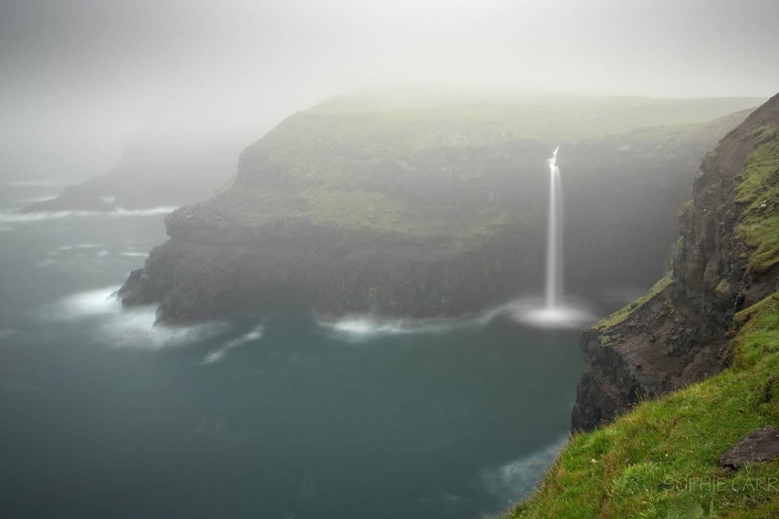
After an early start, flying first to Copenhagen and then to the Faroe Islands, we finally arrived in the islands in the heaviest of fog. And drizzle. Our B&B owner picked us up as we were renting our car for the week from him. It wasn't a great start, but we made it up to Gasadalur which looked fantastic and atmospheric. We also saw our first puffins, so out came the rented 100-400mm lens and Sophie was a happy girl.
 |
| We arrived in heavy fog, but managed to at least visit the magical Gasadalur - I actually think it looks better in these conditions |
 |
| Yay - first day and we spot puffins! |
Day 2 - Vestmanna to Vidareidi
I'd organised the trip to pack quite a lot in (as usual), so the following morning was up early and off to Vestmanna to take a boat trip out to see the allegedly stunning cliffs. We should've checked the weather and the cancellation policy with the staff, but I didn't think to ask - the seas ended up being too rough to go to the cliffs, so instead we sailed along a fjord and it was just a bit meh. There were a few gannets flying and diving around us which was a bit of a consolation prize, I suppose. The place was also streaming with pretty waterfalls and some nice inlets.
 |
| Terribly disappointing boat trip to see the Vestmanna cliffs - got part of the way out there and the sea was too rough so we turned back and went along the inside of the fjord instead. Saw some gannets though, which was nice! |
 |
| The only view we got of the cliffs before heading in along the fjord |
 |
| Gannet flyby - they're massive! |
 |
| Cute guillemot couple |
 |
| Loads of sheep huts everywhere! |
Next on the agenda was driving all the way to Klaksvik, where we were spending two nights, and then straight on to Vidareidi - the furthest away town on the island of Vidoy. Great views from up there and the sun even came out for us. The route there took us through our first single-lane tunnel, where you have to guess how far an oncoming car is in order to pull off to the side in time for it to pass. Fortunately there's not a great deal of traffic.
 |
| A patch of sunlight on the drive across Eysturoy island - this one is called Sydrugota |
 |
| View from the northern tip of Vidoy island at Vidareidi across to Fugloy island |
 |
| View from Vidareidi across to Bordoy and Kunoy islands |
 |
| The pretty town of Vidareidi, with the massive Malinsfjall, which apparently isn't visible very often. The sun even came out for us |
Day 3 - Daytrip to Kalsoy
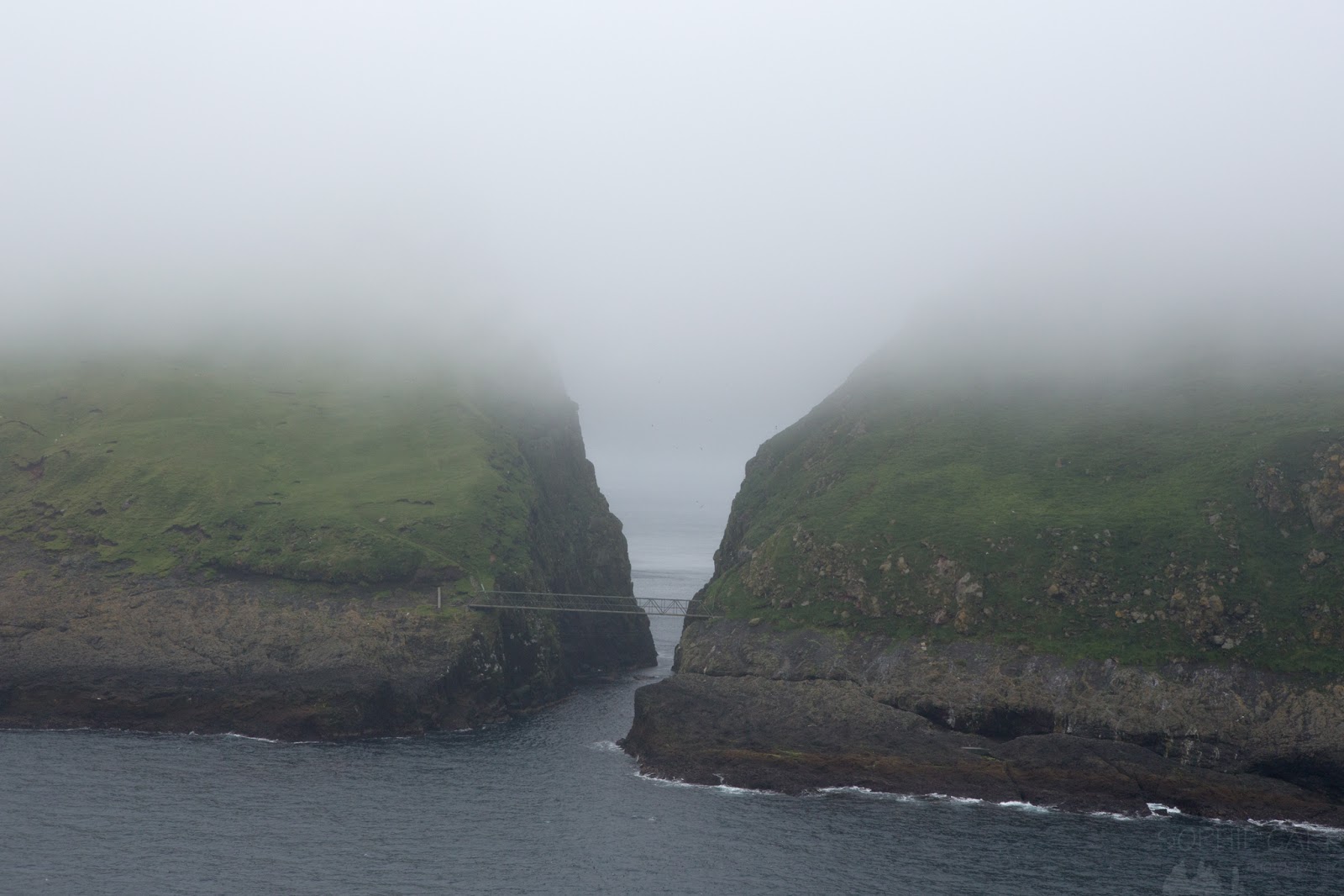
Being based in Klaksvik is great if you want to do a day-trip to Kalsoy and hike up to the lighthouse at Trollanes. We could see the port from our hotel window across the bay, and I saw the cars already lining up for the ferry very early, so we headed over there and only just got a spot, in spite of being early. Tip: show up early for ferries - they're small! And the next one is often a few hours later... The ferry was pleasant and then we drove up the east side of the island through a few single-lane, dark tunnels. Fortunately on a trip like this everyone arrives off the ferry and drives in the same direction, and then drives back later, so we didn't meet anyone in the tunnels.
 |
| There are many delightful churches in the Faroe Islands - this is at Husar, on Kalsoy, on the drive to Trollanes (after a short ferry ride across from Klaksvik, where we'd been staying) |
 |
| The Faroe Islands have a lot of tunnels. Some, like this one, are single lanes and unlit, so you have to pull off to the side to let anyone passing go by. |
The road down to Trollanes is a typical sight in the Faroes - winding, sharp hairpin bends, and surrounded by extremely green grass (the whole place is greener than anywhere I've ever seen).
Day 4 - Klaksvik to Gjogv
On our fourth day we checked out of Klaksvik and headed back west. We were staying in Gjogv for two nights, and this gave us the chance to explore the northern end of Streymoy and Eysturoy. First stop was a foggy and drizzly Saksun - a cute little grass-roofed village with a sheltered bay down below. In spite of the conditions we did a little hike up to the waterfall, and waited a little until all the cruise passengers left - not the best timing!
 |
| Having left Klaksvik in sunshine, the weather deteriorated along the way and we arrived at Saksun in fog and drizzle - typical Faroese weather |
 |
| Grass-covered houses, a cute church, pretty waterfall - what more could you ask for? |
 |
| Just after we arrived at Saksun a coachload of Canadian cruise passengers arrived - this is taken after the last one left |
 |
| Got the tripod out briefly to capture the waterfall |
Once we left Saksun we briefly stopped at Fossa - a tiered, massive (and permanent) waterall. Many of the falls in these islands are temporary, just taking the recent rain off the hillsides down to the sea. It reminded me of Iceland :)
 |
| On arrival at Gjogv we went for a quick hike up the hill. Anyone else see the troll?! |
 |
| View of Gjogv after a little hike uphill on the other side of the gorge |
 |
| Another view from the hill above Gjogv |
 |
| Back down in the village is a pretty church and the sun even deigned to come out |
 |
| Explored along the coast a bit and I was delighted to find some basalt cliffs! |
 |
| Cute colourful houses in the village of Gjogv |
 |
| Lots of the traditional houses in the Faroe Islands are painted black - especially the ones with grass roofs |
 |
| A bit of colourful lichen on the rocks at the beach in Gjogv |
 |
| Exploring the cliffs around the opening to the gorge at Gjogv |
 |
| Rockpool on Gjogv beach |
 |
| Exploring down in the gorge at Gjogv (which is gorge in Faroese) |
Day 5 - Exploring Eysturoy
Perfect day for a hike! We wanted to hike up the highest mountain on the islands - Slaettaratindur, and despite some low cloud, the visibility was still pretty good. I didn't bother taking any DSLR photos on the way up, which of course was a mistake. As we headed around to the west to get to the top the fog began to come in. I thought it might clear, and we waited at the top for about half an hour, ever hopeful. It cleared in patches occasionally, but was there to stay, moving quickly over and around the peak. Eventually we gave up and headed back down. It was a nice hike anyway!
 |
| It was clear all the way up Slaettaratindur until we were literally five minutes from the summit. Then the fog came in and stayed. There was the occasional break, but mainly it lingered - very disappointing! |
 |
| Hubby sheltering and reading on his kindle while I moved around the summit, hoping for a break in the fog |
 |
| Yay! A brief break in the fog gave a view across to Kalsoy where we'd hiked a couple of days earlier |
 |
| Hikers going up Slaettaratindur after us |
On the road back to Gjogv I'd read about a quick hike up to a ridge (above Funningur) which has good views. Again, fog and disappointment :(
 |
| Next hike was from the road above Funningur. Again it was foggy but I hoped it might be clear once we got to the top. Alas no, just a little view down to the fjord below |
We spent the rest of the day driving around the little villages of northern Eysturoy - very pretty, and no tourists, which was nice. No Canadian cruise passengers!
 |
| Exploring little villages in Eysturoy - this is a church at Hellurnar - don't think many tourists venture down there |
 |
| Another marvellous hairpin bend - this one on the way to Hellurnar |
 |
| A bench overlooking Hellurnar - they love their benches in the Faroes - there were plenty |
 |
| Green farm building in Oyndarfjordur |
 |
| Highland cow in Oyndarfjordur |
 |
| Old farm building in Oyndarfjordur |
 |
| Buttercups overlooking the pretty village of Oyndarfjordur (the little country roads are nicknamed "buttercup roads" - this place explained why! |
 |
| View from Oyndarfjordur across to Kalsoy |
 |
| Another cute church - this time in Elduvik |
 |
| The east side of the village of Elduvik |
 |
| Such cute houses in Elduvik with the traditional grass roofs |
 |
| Another grass roof in Elduvik |
 |
| And another... |
 |
| And more! Elduvik was one of the cutest villages we visited |
In the evening we had a traditional Faroese meal and some entertainment - two girls - one on a accordion and the other on a clarinet - quite impressive, although could have given the buffet a miss!
Day 6 - Gjogv to Torshavn
We woke up to a beautiful morning in Gjogv, so decided to give the quick hike up from the road another go. There was some patchy fog and lo and behold it greeted us at the ridge. It came and went, but we did get some brief views.
 |
| We woke up to better weather in Gjogv, so attempted the hike up above Funningur again. And again the fog arrived... |
 |
| A quick break in the fog gave us a view of Elduvik on the other side of the fjord |
 |
| Our penultimate day saw us drive back to our starting point at Vagar. We drove past the town of Eidi again |
 |
| Some blue skies over the bridge at Oyrarbakki - this bridge actually crosses over the Atlantic Ocean here! |
One hike I really wanted to do while I was there was out to the coast where there's a view of a lake that looks almost suspended above the sea. We'd intended to do it on the afternoon we arrived, but there would seriously be no point doing that kind of hike if you couldn't see anything. But today it was warm and sunny and just lovely. The views of both the lake from Traelanipan and the Bosdadfossur waterfall were spectacular. It was pretty scary looking down at the cliffs below.
 |
| We'd wanted to hike out to Bosdalafossur on our first afternoon in the Faroes, but the fog put an end to that idea. Instead we did it on our second opportunity and boy was the weather marvellous. And the views! |
 |
| What a view! |
 |
| More loveliness on the way to Bosdalafossur and Traelanipan |
 |
| Fog lingers over the sea in the distance. Always fog somewhere in the Faroes |
 |
| Seriously, the hike to Bosdalafossur on a lovely clear summer's day is truly wonderful |
 |
| The pretty Sorvagsvatn or Leitisvatn - not sure why it has two names. Anyway, it looked like a heart from this angle |
 |
| The first view from Traelanipan when you see the weird effect of the lake floating above the sea |
 |
| Such a weird old world we live in |
 |
| Looking down over the edge of the cliff to take this shot was a little nerve-racking - I ended up reaching my arms out with the camera and hoping for the best. No option for tripod. Wide angle lens a must! |
 |
| The Faroe Islands in a Nutshell - awe-inspiring scenery, fog and sheep |
 |
| The waterfall isn't bad either |
The walk back was pleasant and still warm, passing curlews and a few little brown jobs, with nice views of Trolkonufingur in the distance. Our necks even got sunburned, which was a little unexpected. We were staying that evening in Torshavn (nothing's very far away!) but did a little detour to the picturesque town of Kirkjubour, where the village is full of black-painted houses with pretty red window frames.
 |
| On our wander around Torshavn we found the wonderful Mikkeller Bar - quite possibly the coolest bar ever! We popped back after supper and had the most incredible sour beer - never tasted anything quite as sour in my life (Spontan Penta-druple raspberry) |
 |
| A delicious flight of Mikkeller's finest |
 |
| Locals in Torshavn in traditional dress (him, not so much) |
Day 7 - Foggy Trip to Mykines
On our last day, I was full of worry and stress. On the night before flying out to the islands I'd received an email from Koks restaurant informing me that a vacancy had come free for us to have dinner there on our last night at 6.30pm (I'd been sent a link to a New York Times article about it from two friends, looked it up and sent them an email to get on the waiting list - worth a try!). I hummed and hawed, as we had a tight schedule planned for that day, and there was a high likelihood of missing the reservation. The first problem was the helicopter. I'd managed to get us seats on the morning helicopter from the airport at Vagar to Mykines, an island full of puffins and gannets. The plan was then to spend the day there hiking and bird-watching, before getting the ferry back to Sorvagur (tourists are only allowed to take the helicopters one way per day, to prevent them taking the place of the locals - and they are dirt cheap). This would get us back with about 30 minutes to drive to the meeting point to get to the restaurant and just make it in time. In order for this to work we decided that we had to leave the car at the ferry terminal, so that we could drive straight from there. This meant a 4km walk uphill (in the drizzle) in order to get to the helicopter first thing in the morning. It was a good plan though. The helicopter took off in spite of the low visibility and off we whizzed passing the little island of Tindholmur and lots of salmon farms.
 |
| We had a rather stressful day lined up for our last one in the Faroes - starting with a helicopter across to Mykines. Including the flight back to Vagar, it was the only trip they flew that day because of the fog. We'd driven to Sorvagur, where the ferry arrives back from Mykines, then walked up the hill to the airport for our helicopter. There was a method to this madness... |
 |
| Flying along the coast of Mykines in a ridiculously cheap helicopter (you're only allowed to fly one way per day, hence the stress...) |
There was a little visibility when we arrived in the village, and we headed straight off to go and find some puffins. You're supposed to pay to get in these days, but we would have had to have waited around for half an hour for the guy to appear so we decided we'd do it on our return, if necessary.
 |
| Arriving in Mykines village in fog - the weather was not promising for a 3-4 hour hike to see birds |
 |
| The helicopter departs, leaving us stranded on the island, hoping the boat would arrive on time in the afternoon |
The hiking conditions weren't ideal, but it's a nice enough hike up and down and around the island. It wasn't long before we saw our first puffins up close. There weren't very many around until we reached a couple of misty colonies.
 |
| One of my favourite shots from 2018 - this adorable wee puffin peaking out from its burrow just below the path around foggy Mykines |
The scenery wasn't bad either - it must look amazing on a slightly clearer day...
 |
| The next stress of the day was worrying about whether the boat would come to the island to pick up all those of us who'd travelled out that day (mostly by boat, only a luck few by helicopter!). Time was tight, as we had secured a last-minute table at the Koks Michelin-starred restaurant. If the boat was late it might have messed up the reservation. |
 |
| Luckily the boat was on time, and we made it back to Sorvagur on time |
 |
|
And so we made it back in time. We got in the car and drove straight to the meeting point for Koks, which is a car park near a tunnel once you reach Streymoy. We quickly changed out of our wet weather clothes into slightly nicer gear (er, jeans instead of hiking trousers) and then wandered down to a hut next to a lake where we were greeted. I'm not going to go into much detail, other than to say that the whole experience from start to finish was quite magical. The food was sublime (with a couple of minor exceptions), with about 20 small courses in all, with local things grown on the hillsides and in the ocean. Unfortunately I had to drive back to the B&B so was unable to enjoy the wine pairing (hubby did) but paired my dishes with juice instead. We met a few of our fellow eaters (including a couple from the other London, in Ontario). Sadly the chef was having a night off with his family, but it didn't detract from an incredible night to finish off our week on the islands. Quite the splurge, but worth it.
We flew out to Copenhagen the following morning, when obviously the weather we left behind was stunning again. Oh well, at least I got nice views of the islands as I left.
 |
| Leitisvatn/Sorvagsvatn from above - quite nice! |
 |
| Flying over Sandoy - one of the southern islands that we didn't get to. Next time... |
And here's a map of all the places we went (red lines because I couldn't add those bits on Google Maps because of the boat to Kalsoy and helicopter to Mykines).
 |
| All this on less than a tank of petrol - it's small! |


No comments:
Post a Comment