I managed to get myself up pretty early, although by the time I set off the sun was beginning to rise; even a 7am sunrise is a struggle for me! I headed east, stopping at a pull-out a few kilometres from the hostel. I noticed that the moon - which had been full the previous night - was just about to set, and looked enormous above the hills, which were glowing slightly red as the sun began to rise. I couldn't be bothered to get the tripod out, so just ramped up the ISO and took a couple of handheld shots.
I drove onwards, keen to get to Hvalnes to see the rock (hopefully) lit up as the run came up. I stopped up near the little lagoon and watched swan families gliding gracefully in and out of the shadows.
I drove on and parked up near the lighthouse. It was empty. I didn't venture very far, but took a few shots of the slopes of Eystrahorn.
And of course I had to take a few self-portraits - I always do here. And it was a nice still morning, so I was able to strip down to the lopapeysa and hair wasn't flying everywhere.
Next stop was Fauskasandur, where I'd stopped back in the winter. It's not an easy spot to find a decent composition - or perhaps I just need to explore a little. I ended up taking most of the shots of the stack from the headland.
I must return at a time other than sunrise, as that also limits what photos work - eg. shooting out to sea with the sun behind just results in lens flare. There are some interesting rock formations just offshore, so perhaps at lower tide it also might reveal more.
As I stood on the headland I noticed that when a particularly big wave hit the rocks below me there was a massive boom audible, and I think I could feel the ground move a little. Not sure if that's possible, but that's what it felt like. It was quite incredible! The power of the sea never ceases to leave me awe-struck. It is so relentless, the waves continuously smashing against the shore, over and over. I took a few shots of the waves with a filter or two on to slow the movement down a little.
As I left the rocks an Asian couple arrived and the woman exclaimed how scary it was, giggling as she went. It is not a scary cliff in the slightest (for me) - amazing how different people's perception of danger is. I walked down onto the beach and took a few last photos of the waves crashing against the rocks that I'd been standing on top of.
I could've spent all day there really, exploring the area a bit more, but I was planning on a long hike into the canyon later, so headed back home. I stopped at one of the pull-outs along the scary raised section, where a tour group had just pulled in. The view back along the coast was wonderful.
I drove on past Hvalnes, and then stopped at a spot where I had a lovely view of the swans, with the backdrop of the mountains on the far side of the lagoon; the light was magical on the autumnal grass.
Just before the very tight bend I stopped again as there were some pretty autumnal trees at the foot of a small hill. I walked back along the road to try to get a better view, but it wasn't really working. I did find a lone lupin, though, which was nice. It must look magical in the summer when the lupins are in full bloom.


I got home at 9.40am and had some breakfast, before making myself a packed lunch and setting off for the big hike. One of the main reasons for this route (along the south coast to the south-east) in the autumn was to be able to visit the Hvannagil Canyon, which lies north of Stafafell. In the winter it is inaccessible (probably), so I've never ventured there before. I knew that there were colourful hillsides with rhyolitic rocks. I set off at around 11.15am. The walk there was glorious; it was such an amazing day, with little wind, and not too cold. I headed uphill for a while and then the walk just meandered over smaller hills, the views around just divine. At one point I could see down to the braids of the Jökulsá í Loní river - how I love those braids!
It wasn't long before the rhyolitic hills came into sight; they reminded me of the Bolivian altiplano, but without the cold and the altitude to contend with.
I passed various little valleys that led down to the main river; birch trees dotted around the hillsides.
After just over an hour of walking I reached a spot with a view of a lovely waterfall falling in an interesting ravine - one day I will get a bit closer and explore more.
I got quite excited as I approached the top of the canyon, the colours and shapes began looming into view.
I finally reached the end of the approach walk and stood at the top of the canyon wall. The colours and shapes of the eroded valley were incredible. The light was tricky with harsh shadows, given it was the middle of the day, but it was still striking.
At first I couldn't see how I was going to get down, but eventually a path came into view as I walked a little along the top of the canyon on loose stones. The path down to the canyon floor was pretty steep - I was glad I was going down and not up it! A river flowing at the bottom seemed a very long way down.
The colours of the canyon walls varied - lots of blues, greens, purples, oranges and yellows, with veins of rock passing through. A geologist would have a field day here.
As I reached the floor I walked through autumnal birch shrubs. Some areas above the river were grassy; it was quite lovely, and being alone made it even more special.

It was a glorious day and a wonderful hike. I wandered along the edge of the river, crossing over from time to time, marvelling at the formations I passed.
From time to time the scenery became devoid of plants and reminded me again of the Bolivian altiplano. Just stunning!

I got to one bend in the river and realised that there was no way to jump across the whole section. The options were to take my shoes off and roll up my trousers and wade through, or to just try the jump and hope for the best. I did the latter, and it wasn't very successful. One foot ended up getting completely wet, so I sat down on the beach, took the shoe and saturated sock off, wrung it out and laid it on the beach to dry in the sun for a bit. I'd brought a spare pair of socks and a small travel towel, thinking this might happen, and I tried to absorb some of the water in the shoe with the towel. I got out my sandwich and just sat there for a while, enjoying the view. At one point I decided to lie down - not something I do very frequently outdoors. I lay on the hard stones, looking up at the blue sky, watching a few clouds waft past, feeling quite blissful. When I felt the shoe was dry enough I've walked up a little hill nearby and had a view of the river zigzagging up into the canyon.

I continued on a little way and came to a rather odd bit - the river just stopped. It was flowing until the point at which it just stopped, which I couldn't understand; I guess it must've gone underground a little, as it continued to flow further down the beach.
Not only was I fascinated by the river ending, but I also noticed the wonderful zigzags behind me - with layers of rock and the river sharply changing direction. I was in love with the place, that's for sure. Definitely worth the visit in the autumn, although who knows what it might be like in winter... A few self-portraits were taken, until the wind picked up and I got nervous that the tripod might get knocked over.
I checked my watch; it was 2.30pm. I wanted to head to Stokksnes for sunset, so I did have a bit of a time limit, and I still had a very long walk back to the hostel. I was out of the canyon pretty quickly, and was sad to say goodbye to it. The view back towards the opening of the canyon was also spectacular, with huge cliffs reaching upwards from the wide river valley.
I'd read someone's trip report saying that the walk back from the canyon wasn't very interesting, so I was prepared for another 7km or so without much to photograph. The person was wrong; it was a lovely walk! Almost immediately I saw summer houses nestled at the foot of hills, the braids of the river reaching out ahead of me, autumnal trees everywhere. It was a long walk, and being along a gravel road made it a little less interesting than across hillsides of moss and shrubs, but the views were still spectacular. There were lots of different rock formations along the way.
The snowy peaks were visible above the trees from time to time.
Occasionally the view of the river braids would be better as I rose a little above the river bed. The wonderful Brunnhorn also returned to view.
There were even some basalt columns to make me really happy.
It was certainly not a dull walk.
I was pretty exhausted by the time I reached the road, but relieved knowing that I only had a few more hundred metres to go, passing the farm and then the pretty little church opposite the hostel's entrance.


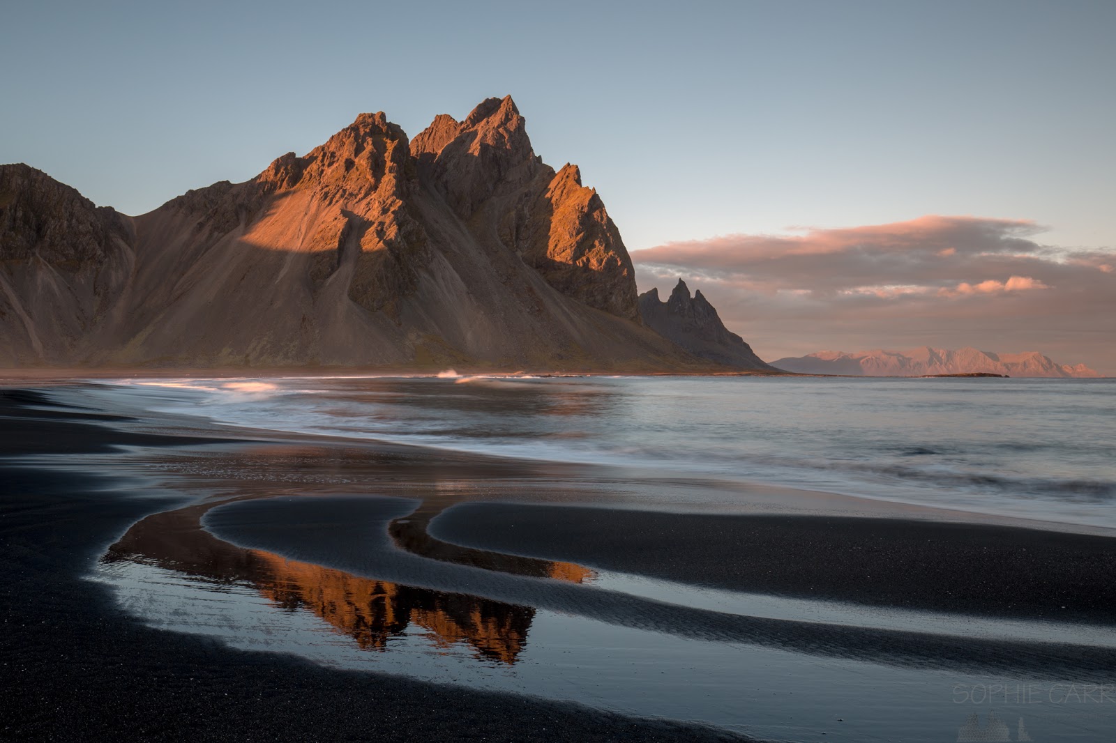
I got back just after 4pm, so the whole hike took just over five hours, which wasn't bad going since I had stopped a fair amount. It was an incredible hike, and made the whole trip (and decision to come on this route) worthwhile. I had a cup of tea, and relaxed for a while, but headed out just after 5.30pm, as I wanted to get to Stokksnes beach for sunset, camera and phone batteries all recharged. I paid my entrance fee at the café (which now gives you a ticket with a barcode that operates a barrier across the road) and then drove across the spit to the parking area just before the entrance to the radar station. There were quite a few people there, unsurprisingly, but it is a big place, so enough room for us all, I suppose. I wandered down the usual route, along the path near the fence, past the little pool, and onto the rocks at the far end of the beach. It was magical as usual, although I could have done with being there about twenty minutes earlier...

I wandered along the beach a bit and took the usual selection of photos, mostly with a couple of filters on. At some point, disaster struck (more on that later).
The beach at Stokksnes is a wonderful place for photography, with waves over rocks on the beach, pools and wet sand reflecting the mountains, incredible jagged peaks, cool black sand dunes with tufty grasses blowing in the incessant wind, and of course the panorama of the whole mountain range that is possible to capture with a wide angle. It is also a difficult place to capture something original, as every angle has been covered before. I notice that all of my shots look similar to a previous visit. Oh well, it's still bloody nice!


The light faded and I was a bit exhausted after my long and eventful day - the tiredness of walking 10 miles (plus a bit more) had caught up on me. The northern lights forecast was disappointing and I didn't have the energy to take any star shots. I walked back through the dunes to the car and heading down the spit. I stopped about half way down as I noticed some rocks in the lagoon and the moon just peaking over the horizon. The moon rose up behind scattered clouds - it was wonderful, like the night at Jökulsárlón, but I had to tear myself away eventually as the tiredness was growing and I still had a twenty minute drive home.
I got home and cooked the last remaining piece of fish and reviewed my photos from the extremely long day. As I went through the last ones - taken with the wide-angle lens at Stokksnes - I noticed that across the top right of each photo taken at less than 30mm there was a massive hair visible. The photos weren't totally ruined, but photoshop was necessary to rescue the sky. I was so annoyed with myself for not having noticed. The weather forecast for the morning was good, so I set the alarm for 6am and got an early night.
 |
| My route from Day 6, including the 10m hike to Hvannagil Canyon |
Click here for my blog from
Day 5 - Jökulsárlón to StafafellClick here for my blog from
Day 7 - Stokksnes and Friends


No comments:
Post a Comment