Showing posts with label Mustang. Show all posts

28 Aug 2016

Road-trip in Oregon - The Samuel H Boardman Scenic Corridor

[Been a bit distracted by day-job, Iceland planning and Olympics, hence the delay in the blogs!]

We were spending two nights in Gold Beach, which gave us the day to explore the Samuel H Boardman scenic corridor - a long stretch of the southern Oregon coastline dotted with little tree-topped islands, nestled between bays and headlands, hidden beaches around every corner. I'd seen a few shots on Flickr and wanted to find a particular spot, and had a pretty good idea of where it was, so would try to locate it during the day prior to returning to capture it at sunset.

After breakfast in the motel we set off out of town, the weather a little overcast, but with some patchy blue sky. I had expected the road to be prettier (all down the coast, actually), but it was a busy two-lane highway in places, so not exactly the quaint scenic drive I'd hoped for. We drove the length of the road first, deciding to then stop on the way back, pulling in at a couple of the roadside pullouts to enjoy the view.


The first proper stop was Lone Ranch Beach, a long stretch of beach just off the road, with a few stacks in the bay. The light wasn't great, so black and white conversion was in order for a few of the shots.


We continued north, looking for a trailhead that I'd decided on to start a long-ish hike. The plan was to hike from Indian Sands to China Beach and back. The trouble with this park - from a hiking perspective - is that it's spread along the coastline, so any round trip involves retracing steps along the coastal paths or walking along the road. We parked up at Indian Sands and headed north. We got a little lost to start with, ending up at the road a little further along. We walked back to the car and started again, heading this time down towards the sea. We found the trail to the dunes of Indian Sands before coming to an apparent dead-end (with a nice view).


I'd read up on the trail and it certainly didn't end there, so I had a little snoop around and finally found 
the narrow trail winding up around the side of the headland, so we continued on.

The trail took us back uphill through thick pine forest, with occasional breaks in the trees affording us glimpses of hidden bays and more little islets sitting in the frothy surf.


We soon realised that we were going to have to go back up to the road in order to cross the massive bridge at Thomas Creek (the highest bridge in Oregon, at 345ft or 105m); there was no obvious way down to the bottom of the creek and back up the other side. The bridge is pretty long and impressive, and in the middle I stopped to look down - enough to give anyone a little vertigo. Piles of driftwood sat alongside a thread of rivers which glistened in the midday sun.


Finally on the far side we got a good view of the bridge behind us.

O
On the other side we had the choice to find the trail on North Island (another little headland) or head down through the forest towards China Beach; we chose the latter route.


China Beach is a long stretch of grey-ish white sand with - of course - a series of stacks sitting just off the beach. We sat on some rocks and ate a packed lunch, the sky now nearly completely blue, with just a few wispy cirrus clouds left.


W
We continued along the beach, noticing piles of pink crustacean shells and barnacle-covered mussel shells. I had a look for cowrie shells but found none :(


We spotted the trail at the far end of the beach, sign-posted with a "Coast Trail" sign. A woman and her child played in the sand as we headed back up the hill.


The path rose steeply through more pine forests to the road. We had the choice of walking back along the road (the quick but not very nice route) or following the same route back down via Indian Sands. Neither of us had the energy to go down and up again, so we decided to stick to the direct route along the road. I still wanted to stop at some other pull-outs and viewpoints, so this was the quickest way back to the car.

We pulled in to park at Natural Bridges, where I hoped to find the spot that I wanted to scope out for sunset, later on. We walked down through thick undergrowth and came out at a lovely viewpoint overlooking the bridge.


W
We carried on further, hoping to find a path off the trail down to the viewpoint, but it was blocked with a sign saying closed due to nesting birds. Hopes of my perfect sunset shot were dashed. We carried on a bit further but there were no other trails leading us to the place I wanted to see. There were some other decent views, but not the specific one I was hoping for!


W
We wandered back up to the car, drove a hundred metres down the road to the next parking spot at Thunder Rock Cove and I headed down the trail to scope out that area; hubby stayed in the car. I came to a lovely little headland, with some natural arches and hidden beaches (one aptly-named Secret Beach) and views north and south. A couple of sea otters floated below the arch. This spot would have to do for sunset, later, although the position of the setting sun was going to be challenging.


W
We drove back towards town in search of the Arch Rock Brewing Company, which had won a prestigious very small brewery award for one of its beers. We drove into town but couldn't find it, checked Google Maps and drove back out to find it hidden away in a little area called Hunter Creek. The tap room was basically in the entrance-way of the tiny brewery, and a friendly man gave us some samples. We bought a couple of plastic growlers and filled them up with an interesting absinthe porter ("Another State of Mind") and a decent pale ale ("Pistol River Pale Ale"). We ate dinner in town in a strange little restaurant that also stocked the beer, Barnacle Bistro. After an okay meal we headed back to the hotel to recharge batteries and get some thermals for the sunset shoot a little later.


W
We drove back to the Thunder Rock Cove car-park and headed down to the little promontory, the sun still fairly high in the sky. I wandered around the paths to see which compositions I liked the best; nothing truly grabbed me. Eventually I spent most of the following hour capturing the backlit trees on some rocky cliffs above Secret Beach. The rocks to the south eventually began to glow too as the golden hour intensified.


Just before the sun actually began to set I started scurrying around searching for better composition, but the positions of the stacks, islands and the sun just weren't doing it for me. In the end I settled down to photograph the sun on its own, as it passed behind an animal-like cloud before reappearing briefly and then dipping behind the ocean.


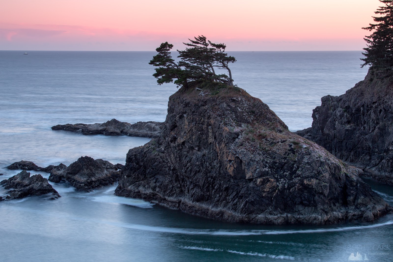
After the sun had gone the sky to the north-west glowed a warm peach, and to the south-west the horizon became pink.

T
To the south the rocky crags lost their colour and the sky and sea both turned a lovely soft blue. 

I packed up my tripod and we headed back to the car, noticing that the Mustang sign lit up the ground below, rather unnecessarily!


W
We headed back to the motel and had a quick beer before an early night. The following day we were heading inland, our trip to the Oregon coastline, and the worry in the back of my mind of tsunamis, being left behind us.

If you're interested in visiting this state park - this is a great little booklet to help you!

Map of the day's route

Click here for Yachats to Gold Beach blog
Click here for the drive to Crater Lake blog

26 Jul 2016

Road-trip in Oregon - Cannon Beach, Tillamook, Rogue Brewery & Yachats


The day started early - around 5.10am, before it got light. As we were staying overlooking Cannon Beach I really had no excuse not to make the effort to get up. I'd got all my gear ready before we went to bed so as not to disturb hubby and I crept out, climbed down the stairs and made my way across the beach towards Haystack Rock. The sky was heavy with cloud and there was a light sea fog. The tide was in past the rocks, but was on its way out, and the sand was still wet and reflective. I tried a few shots fairly far away from the rock, using my wide-angle lens, before heading south along the beach. The amazing thing about beaches with stacks is that there are just so many options for different compositions, with the stacks placed in different arrangements.


The sky began to lighten pretty quickly, but the clouds lingered, revealing only a small bright patch to give any hint that the sun had risen behind them. The thin veil of sea fog lingered over the houses behind the beach; the hills to the south just visible in the foggy air. At 5.45am I noticed my first companions on the beach, two figures barely visible in the distance.


As I walked towards them, further down the beach, I didn't really like the view back towards Haystack Rock - somehow it looks better flanked by the smaller stacks on either side. I walked down towards a large barnacle-encrusted round-ish rock that sat in it's own round pool. I realised that the tide was going out soon, leaving rock-pools, rocks covered in seaweed and reflective sand. Looking back at the photos it's amazing how stumbling on a perfect composition can sometimes be just by chance, and then the moment will be gone as the tide takes it away (click here to see the response on Flickr to this particular shot!).


By 6am the sky was changing colour a little, but nothing spectacular, sadly. I wandered back towards the hotel and tried some long exposures, like this 4-minute one. With exposures that long I was able to get the clouds streaked pleasantly across the sky, even if there was no decent colour.


More people could just be seen in the salty air, taking a fresh early-morning walk with a companion and some with dogs.


At 6.45am a pick-up truck with a trailer drove onto the beach and a ranger got out and began bringing signs down to the edge of the rocks at the foot of Haystack Rock. The tide was out now, and these signs reminded visitors to keep their dogs on leads and gave some information about the Oregon Islands National Wildlife Refuge (there are lots of rock-pools scattered at the foot of the rocks). A few photographers had begun to arrive, their tripods silhouetted against the fog. I walked back south again for a bit, wanting to get some shots of the ethereal hills, but without the truck in the shot! I took some long exposure shots of the smaller stacks and small rocks in the surf (there was a little wave action, but not much).


I wandered north again, passing a ranger with some photographers (birders, I think, as they were close to some bird nests and I could just make out some little guillemots - the ones with the white patches and red feet!). I noticed some interesting bits of life in and around the rock-pools, including some rather bizarre creatures and sand-covered anemones.


By 7.45am I finally gave up, now thoroughly hot and sweaty in my thermals and fleece, and headed back up the beach and the stairs to wake up hubby. We packed up and headed out, hoping to go to a highly-rated coffee shop (Sleepy Monk) across the road. Unfortunately it was closed (on a Wednesday!) and so we wandered up the road to see what else was on offer. Not much, sadly - a bagel shop that was supposed to be closed on Thursdays was closed, and another coffee shop had a couple of rather sad-looking pastries left, so we headed back to get the car and drove to Pig 'n' Pancake - a west coast chain we'd passed a couple of times. The place was large, and heaving, but was definitely what I'd call "hip", more of a typical cheap and cheerful place where the portions were enormous and the food okay. We tried to order coffee but were rather confused as all of the coffees (including espressos) came as either single tall, double or double tall. We ordered a double latte and ended up with an enormous glass of extremely weak milky coffee, with a straw in it, which stupidly (because it had a straw in it which made me not think!) I drank through and burned my tongue. We ate Eggs Benedict with crab, which was a little odd, and potato pancakes with bacon and apple sauce, which were quite tasty. Feeling utterly stuffed after the mountain of coffee we drove back to pack up (the hotel had a nice late 12pm check-out time).


I took a last few shots of the beach under white overcast skies. Some people played around on bicycle go-carts and the area in front of Haystack Rock was teeming with visitors - they looked like ants beneath the 235 foot high monolith.


We were driving down to Yachats, about half way down the coast, planning to visit the Tillamook cheddar factory, the Rogue Brewery at Newport, before staying at a rather expensive resort in Yachats with a jacuzzi bath overlooking the sea. It was our first overcast day, which was a shame, since we'd be driving down the coastal road through lovely scenery. In fact, it was positively miserable as we headed south, stopping briefly to look back at the foggy view and capture the windy road ahead. We still drove with the roof down, just with fleeces on this time, and the heated bumped up.


We arrived slightly inland at Tillamook just over an hour later, after a rather dull drive, apart from the first windy section. We pulled into the cheddar place and decided to go on the free tour - to the viewing gallery over a few conveyor belts, watching the cheese chopped, packed and checked. Afterwards we tasted some of the samples of the cheese - it wasn't bad, but coming from a country with really, really good cheddar (and being the home of it), it was just rather ordinary, with a rather soft texture. We tried some cheese curd (like what we'd eaten deep-fried) and it was squeaky like haloumi. Next stop was the ice-cream shop - we both had salted caramel - tasted pretty much like sweet vanilla, but was quite nice.


Next on the day's agenda was the Rogue Brewery in Newport. We hadn't visited their branch in Astoria, so this was a must-stop place. I agreed to drive the last stretch so that hubby could partake in the beer-tasting properly. Before we arrived, though, we stopped at some wonderful viewpoints - Rocky Creek and Otter Rock. We took a little walk through some woodland to a viewpoint at Rocky Creek, passing the delightful grass that I've yet to identify that I loved up on Vancouver Island.

Some houses were nicely placed above little cliffs with private beaches (nice spot for a lottery win vacation home!). We spotted a couple of seals playing around near the shore. We looked for whales but saw none, just whale-watching dinghies speeding by.


The fog was rolling in from the sea, but the sun still shone through. Sadly by the time we reached the little museum at Otter Rock the sea was barely visible, so no possible whale sightings for us! The view along the coast was still stunning, and I just managed to get a shot before the fog obscured everything (through the window!). Apparently whales had been seen just north (where we'd come from) half an hour earlier.


We pulled in at Devil's Punchbowl, again just visible with sea-fog coming towards us. The view south was mainly obscured by fog too now.


As we approached the brewery we had to cross the Yaquina River via the magnificent Yaquina Bridge. I really have never seen so many incredible bridge structures as in this state!


We found the place easily - just off the main road - and got a seat in the upstairs bar at the window, overlooking Newport harbour and the wonderful bridge. We tried some interesting beers, including a Snickers - a little welcome, on-the-house combination of a stout and a hazelnut beer (I was quite taken). We ordered a plate of humous and some crab sliders - all very tasty. I had to hold back and had very small sips of each of the beers, but we made up for it by buying some large bottles to take with us (as well as a couple of t-shirts).


The last section of the drive was lovely, with the sun low in the sky over the foggy sea. We stopped at Seal Rock, where a selection of small monoliths sat on the sand, the fog wafting past, the sun about 13 degrees above the horizon. I took a few handheld shots, struggled to find a decent composition, and also felt anxious about getting to the Overleaf Lodge in time for sunset an hour and a half later. 


We continued on, not stopping until we reached the lodge. It was a nice enough place - not quite as luxurious as I'd thought it might be for the price, and a little old-fashioned, but we had an enormous room overlooking the rocks along the coast. And of course there was the jacuzzi bath... Food was again a problem, as sunset came first, and we knew that all of the restaurants would be closed at sunset.


I did a quick recce of the rocks in front of the lodge, but wasn't massively inspired. Yes, it looked out over rocks and the ocean, but the rocks themselves weren't spectacular (no stacks!!) and I struggled to find inspiration. Hubby suggested driving back up to Seal Rock, but I thought I should just give this place a chance, since we were staying there in our expensive room. I wandered over a few rocks, past another couple of photographers, and took some pictures of the waves crashing against the shore. Again, in a storm it would be quite spectacular, but with clear skies (the fog had gone) it was just pleasant.


I clambered over some more rocks and found a little spot from where I photographed the setting sun with different shutter speeds. It was nice, but not great.


After the sun had disappeared we headed out to Yachats, a couple of miles south, and the only place open was a grocery store selling fried chicken! We ate the chicken at the table in our room, together with a rather vile caesar salad. Just after 10pm we decided to check out the jacuzzi - it said you shouldn't use it after 10pm as it's noisy, but we went ahead anyway - boy it was noisy! We lasted about 10 minutes before I got too hot and felt tired. I wasn't in the mood for any night photography, so we called it a night.
Map of the day's route
Click here for my blog from Astoria to Cannon Beach
Click here for my blog from Yachats to Gold Beach